Design methodology is the process of designing and maintaining a long-term permaculture plan. Permaculture communities can take years to mature, and having a defined and adaptable design process is important to their long-term success. At it’s most basic, the design process is a plan for creating a permaculture community that matches its capabilities with its goals.
Analyze resources — Set goals — Design – Implement – Evaluate — Repeat
This design approach is the same for both large permaculture site designs, and individual projects such as a composting toilet or plant nursery. Whatever project you are working on, remember that most permaculture projects grow incrementally. The design process should focus most attention on the most immediate steps. But also keep in mind the long-term vision. Remain flexible and open to new ideas.
Analyze Resources
Site analysis – Carrying out a permaculture site analysis is the first step in creating a complete site evaluation for your land. The last chapter of this book, Project Planning, contains a template to help assist you in planning your project. This chapter is meant to lay out the general principles so you can start thinking about your design as you read the book. The first set of questions covers general site information:
Roles – It is important to establish the roles and expectations of the project early on: Who are the consultants? Who is the owner or owner’s representative? In many cases the owner is also the consultant.
History – What is the history of the land? What was it used for? What consequences could the land’s former use have on its ability to grow crops?
Surrounding community – Describe the surrounding community. What impact could your project have to the surrounding community? What businesses, industries or services are available nearby that could benefit your project? For example, farming co-ops, hardware stores, tourist attractions, markets, schools, etc.
Soil type – Knowing what type of soil is at your site can help determine the placement of a garden versus placement of a building. You can take multiple soil samples from around your site or near where you want to develop. Learn more about soil tests in the soil section.
Climate – What is the climate like? Tropical, sub-tropical, temperate, arid, coastline. Describe the seasons by months: Rainy/dry season, summer/winter months. What is the annual and monthly rainfall/precipitation? Temperature range? Read more in the Design strategies chapter.
Set Goals
Mission/vision – What is the owners motivation? Why do they want to do this? If you are working as the consultant, try to craft a statement with the owner that can help guide the site plan’s overall theme. Some examples:
- “We aim to be a self-reliant demonstration site using permaculture design principles.”
- “We aim to redesign/renovate our guesthouse to reduce energy and food costs, take greater control of the food we provide, and inspire our guests with more holistic accommodations.”
- “We aim to use part of our property to test permaculture techniques that could be applied in surrounding communities if successful.”
Project Goal Setting – Refer to the list of permaculture principles and choose goals which relate to what you’re trying to achieve at your site. It is also helpful to identify more specific goals to further ilustrate HOW you will achieve each of those goals. These are called SMART goals. SMART stands for Specific, Measurable, Articulate, Relevant and Time-bound. Each of these adjectives help determine HOW a goal can be achieved. For example,
- “Build a dry composting toilet suitable for 10 people using primarily natural building materials by the end of June.“
- “Establish sleeping quarters for 10 people by the end of August.“
- “Grow enough food for 10 people using only stored rainwater by the end of the year.”
Design
Long-term project plan
A project plan in permaculture is the list of appropriate elements for a site. This book is written to present basic options available for permaculture design and help guide one through the decision-making process. Long-term planning is critical for accomplishing work more efficiently and effectively. Be creative. Think big.
Designing for space
Permaculture design is all about efficiency of space. It’s about trying to obtain a higher output within a smaller amount of space. It addresses the question – how can people produce more with less space? To get you started brainstorming, here are some general estimates for minimum quantities of basic living elements per person. All of these numbers are relative. Use these only as general reference points:
- How much water pp / pd? 30 L per person per day
- How much food pp/pd At least 3 sq m per person per day (ref. Square Foot Gardening)
- How many people per toilet? 5 people per 1 toilet per person (min)
- How many people per shower? 5 people per 1 shower per person (min)
- How much sleeping space per person? 3 sq m per person
Existing conditions/permitting
Make sure all planned element and program installations are in line with all local rules and regulations. This will avoid conflict before it happens. What permits are required to do the work you want to do? Is the site zoned for this kind of building? What are the available utilities – water/power/Internet?
Maps
A map illustrates the relative location of things and places in a region or time. There are several types of maps you can create to help illustrate the existing natural conditions of your site as well as your permaculture design.
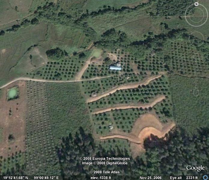
Satellite map
Zoom in to the boundaries of your site or the zoomed in area you will focus on, on Google Earth or Google Maps. Make sure you are in the satellite option (instead of the road maps option) to get a clear picture of the physical surroundings. Then, go to the file menu and scroll down to print, to print an image of your site.
Site map
There are several methods you can use to start drawing a site map:
- You can use the print a satellite image from Google Maps (as described above) or,
- If you don’t have access to a computer, you can walk the boundaries of your site and sketch the perimeter. (Note: Keep in mind this initial site map is just a sketch to be used as a reference guide for a group of people. So getting exact dimensions isn’t completely necessary.)
- Now, on another sheet of paper, draw a clean outline of the boundaries of your property. Boundary lines mark the outer perimeter of your site.
Map basics
Here are a few other elements you could include on your site map:
- Existing structures – Indicate existing buildings, public space, forests, gardens, roads, bridges, paths, water bodies or any other important existing features.
- Planned structures and elements – What you want to do. Gardens, forests, structures. Think about it, discuss it, mark it on the map. It’s okay if it changes – writing it down is the first step to making it real.
- Legend – Include symbols or labels to indicate all information on your map. Include the name of the project, location, climate and your name.
- Scale – Include a scale to show the relative size of the site. Scale can be measured using the printout from Google Maps.
- Compass – Indicate where North is
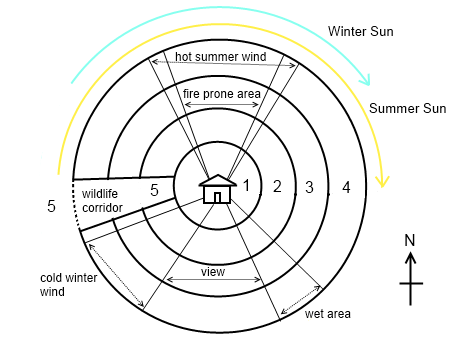
Natural sectors
Sectors are the natural factors that affect the land and the production levels of the land. Consider these natural factors when placing elements around your site as well as when designing structures. Natural factors to indicate on your site map include:
- Sun angles – Sun angles show where the sun shines during the day and at different times of the year. One trick to find sun angles from one position is to face the sun at noon, then stick out your arms in a 90-degree angle from your body (in the shape of a V). This part of your property receives the most sun. You can also sketch the sun angles knowing only the direction of North. If you’re in the Northern hemisphere, the sun will shine from the south. If you’re in the Southern hemisphere, the sun will shine from the north.
- Wind direction – Intermittent wind can damage trees and plants. Plant hedgerows or windbreaks in windy zones to break up the wind before crossing through your site.
- View corridor – Determine where the best views are and design to allow the view to standout. For example, if you have a beautiful view overlooking a river, build structures to allow space so you can see the river rather than building right up against the cliff.
Contour map
Contour maps, also known as topographical maps, mark the changes in elevation in a particular location. The distance between contour lines varies depending on the scale. It could be 1 meter or 5 meters. The difference in elevation of your site determines the scale of your contour lines. Consider the slope, terrain, types of earthworks, and elevation when designing a contour map.
Sometimes contour maps can be found at a local government office. You can draw your own contour map as well. You can include contour lines on the basic site map, or if you will be doing many earthworks, you could make another map to show the contours.
Zone map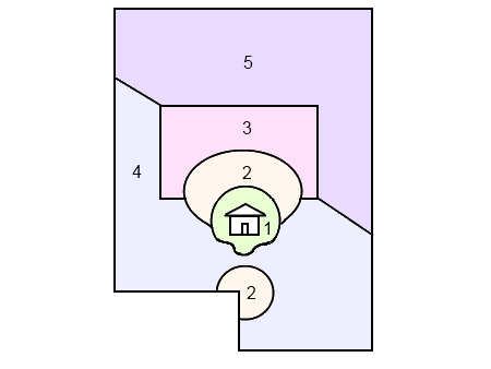
Zones are areas of land having a particular characteristic, purpose or designated use. In a permaculture system, everything we design should be as efficient as possible. One way to increase the efficiency of a site to consider zones and sectors of your site. There are five permaculture zones. Each zone represents a different type of land use determined by:
- How often we visit that element
- How much maintenance is required to that element
- Access to water supply: Zone 1 requires the most, while zone 5 requires the least
Zone 0 – Self or your home
You and your house are the center of your universe. They are your domain. Your center. Design from there.
Zone 1 – Visited many times a day
Zone 1 is the area closest to your house. These elements need the most attention and maintenance. Try to stack as much produce around the house so it’s closer to harvest.
Zone 1 elements: Home, kitchen, shower, toilet, laundry area, clean water, annual gardens, herbs and medicinal plants, nursery, chicken coop, small fish pond, dwarf fruit trees, climbers around house, garden tool shed, compost piles (on the edge of zone 1 and 2).
Zone 2 – Visited once a day
Some elements of zone 2 can be incorporated into zone 1. For example, compost piles are also useful to keep close to your home but don’t necessarily need to be in zone 1.
Zone 2 elements: Perennial gardens, animals such as poultry, pigs, ducks and rabbits, chicken coop, duck house, worm bin, small pond, compost, workshop/tool shed, milking shed, fruit tree orchards.
Zone 3 – Visited once a week
Zone 3 is generally considered as the farm zone. Here we tend to have commercial crops like corn, rice, potato etc. We also have animals for production to market or barter. It contains broad scale farming systems like orchards or food forests. Zone 3 has larger water storage systems like small dams, lakes or ponds for aquaculture and also field shelters like hedgerows and windbreaks.
Zone 3 elements: Crops for market (like corn, rice, wheat, food forest), animals for market or barter (grazing animals), polyculture (integrating different crops and animals together), domestic grain cultivation, swales and terraces, large water stores
Zone 4 – Visited once a month
Zone 4 is generally an area that borders on a forest or wilderness. It is used as larger pasture for animals like horses, cows, buffalo, sheep and goats. Or it can be used to plant tree species for a wood lot to harvest timber for building, wood for fire, thatch for roofing and fodder for animals.
Zone 4 elements: Fruit, oil and nut trees, woodlot, bamboo, grazing animals, a large water source, reforestation
Zone 5 – Visited rarely or never
Typically this zone is a natural, unmanaged environment that is not owned by the farmer or landowner such as a protected forest, nature reserve or land regeneration site. A wildlife corridor can be incorporated into the other zones to encourage native animals and birds onto your land.
Zone 5 elements: Undisturbed wilderness, preserved land
City planning zoning
Before starting a permaculture project, consult with your local council to make sure you are working within legal zoning limitations.
Detail drawings
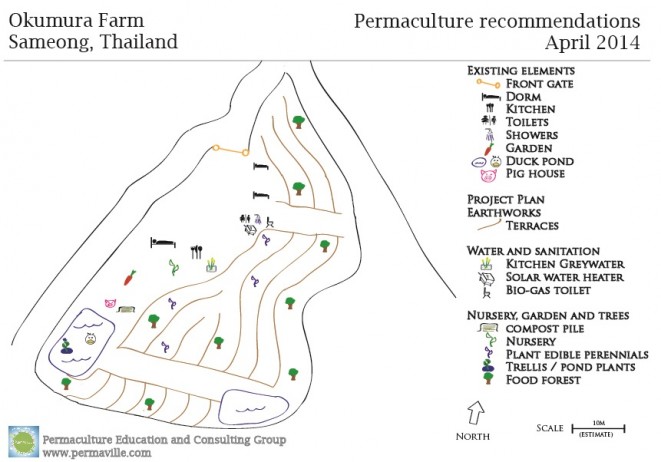
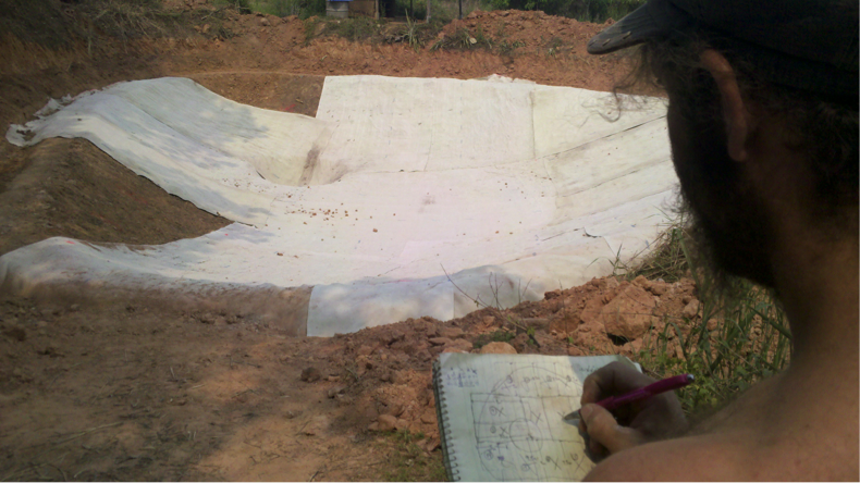
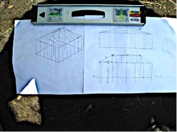
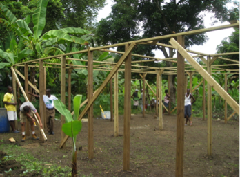
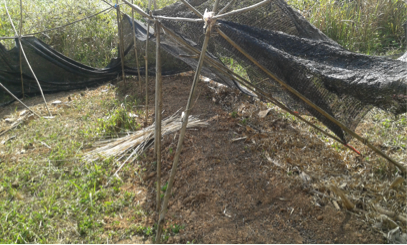
A detail drawing, or detail, is a technical design of something, real or imagined. Some details can be as technical or non-technical as you prefer. Sketches, for example, are a quick, simple, casual way to illustrate an idea. Sketches are not very exact but they have just the right amount of information needed to move forward. They serve as a practical tool to get everyone on the same page. They allow for infinite design creativity at an early stage of the project. Sketches don’t have to be very complex. Think simple. Here are some examples of sketches and their final installations:
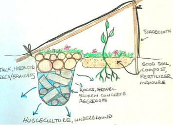
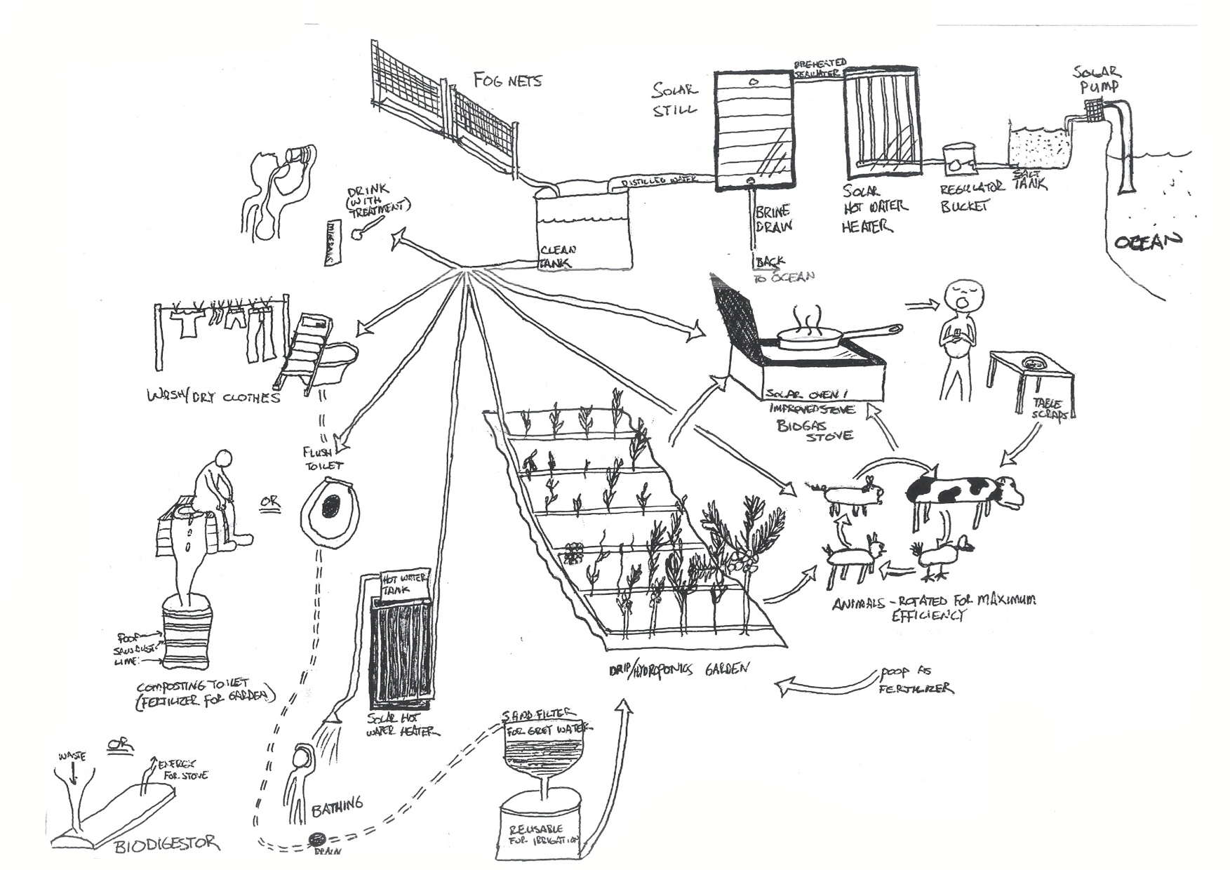
Flow diagram
A flow diagram is a sketch to show how different permaculture elements are related.
Implementation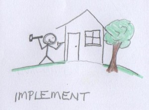
How will you install these first projects? Will it be you by yourself or will you do it with a group of friends? Can other people participate? How? Do you need to raise funds or organize a workshop or a course to obtain the resources, labor or time required?
Project startup
What projects at your site need to be completed right away? Does your site have – access, water and structures? These are your main priorities if starting an empty piece of land. Does the site have a kitchen, toilet, shower, sleeping area, common area? Is it livable? If it’s not, those should be the first things you install.
Phase I elements
Choose an amount of work you think you can accomplish in 1-6 months, with a group of people. What would Phase II look like? Phase III? Include additional phases in your design map but have a strong focus on Phase I. List the name of the element and what general details, materials and costs associated with each element.
Timeline
When will the project start, any major milestones to overcome before starting? Do you have to finish by anytime? How long do you estimate it will take to complete these tasks?
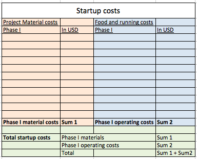
Budget
What will it cost to install phase I of your project? How about the long-term? Consider tool/material costs, food costs, transport/admin and other related startup costs. Keep in mind the long-term plan is likely to change. So keeping a budget of the immediate costs is most relevant. Here’s a template for keeping track of the various expenses of a project:
Available resources
Available of resources can have much value for permaculture communities. When surveying your site, determine what resources you already have that can be used to jumpstart projects. Some examples include:
- Organic materials – Newspaper, cardboard, brown leaves, branches, food scraps like coconut husks, edible food, used cooking oil
- Building materials – Tires, glass bottles, palettes, wood, windows, doors, old couches.
Evaluate
It is important to take time to review the entire design process and determine if there are changes that could result in improvements. Once you complete an element installation, it is important to refer back to the design process and see how you could improve – did you use all available resources, did you achieve your goal, are your results measurable and quantifiable? What went well? What could be improved? Do you need to redo or rebuild something? Is it complete? You are the best judge of a project’s success.
Permaculture design, like nature, is a process. Nothing is ever done. But every project, every element installation, every design must reach a point where you can say, yes, this is good enough. Let’s move forward.